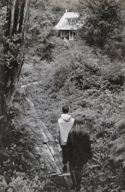
 Hikers approach the Ordway House at Clo-oose on the Ship Wreck Trail, now known as West Coast Trail. Photo and darkroom processing by Dianne Bersea.
 I’ve been riffling through boxes of photos and files. I’m talking about one of those ancient manila folder files with a tab for content descriptions. There’s a lot of strange things in there…, carbon copies (yes “carbon” copies) of old letters I sent, scraps of newspaper articles, and some of my early literary / journalism projects. Among these mysterious papers I found notes for an article about the West Coast trail. A version of this article was published as a three page spread, complete with photos, in the Victoria Colonist weekend magazine when newspapers routinely had a weekend magazine section. Entitled “Even the Rain is Beautiful at Clo-oose,” the events described and the publication of the article happened a lot of years ago, in 1969.
I’ve made some revisions for clarity, hopefully with improved grammar and the occasional aside. I’ve also been inclined to re-interpret the experience and my original journalistic analysis of it. I invite you to join me on this adventure….
**********************************************
On the long May weekend in 1969 an assorted group of like-minded folks from various Vancouver Island outdoor groups, joined together to trek a section of the Shipwreck Trail near Clo-oose. Some drove the rattle producing logging roads from the South end of the Island, and others, like myself, flew from Nanaimo to Brown’s Bay at the western end of Nitinat Lake about mid-point on the now named West Coast Trail.
In a battered Otter float plane we traversed the inland valleys of Vancouver Island on a westerly trajectory, skirting the high mountains that pierce the central island skies. At a near landscape scraping four hundred feet altitude we had good views of the landscape below. The wagon wheel-like scars where logs had been dragged into a central spar pole for transport and the large swaths of clear-cut overwhelmed me. Although I’d heard about the extensive logging in the interior of Vancouver Island I had no idea what that looked like. A rather startling sight.
Overall, the pilot considered the flight routine, despite the ‘low fuel level’ indicator light that glowed brightly throughout the flight.
We splashed down at Brown’s Bay and unloaded onto a partially submerged dock. Finally on the trail, the sight of a dug-out canoe under construction brought us all to a stop. We gathered around the work-in progress for a tutorial in traditional canoe building.
Although justifiably taciturn, the builder shared that his well-weathered Western Red Cedar log on which he worked would be a canoe for his own use and powered by an outboard motor. “Weathered cedar is less likely to crack or split while being worked.” he informed us. The last canoe took the builder only twenty-one days to complete, “but that was without people comin’ round to talk” he pointed out. Hint acknowledged though it appears none of us stepped back to let him work, and he continued to provide a running commentary on his project.
He works without a plan but shapes the canoe simply by eye. The canoe shell itself is only one and a half inches thick when finished. It is then braced with struts and painted. The preliminary shaping was done with a chain saw rather than a carefully directed fire as formerly practiced. Final shaping would be done with an adze in either situation.
As he gave use this information he kept leaping about to conform to the wishes of various enthusiastic photographers. “Little more the left please.” “Could you stand with your hand on the bow, or is that the stern?”
Pressed by one our contingent to confess to his lineage he hesitantly said, “Nitinat Indian.” Further pressed to admit that this was part of the famous Nootka tribe he said, “Well, so the history books tell us.”
Eventually we tired of our crafts and lore exhibition and we pushed off toward Clo-oose. Hot sun poured down as we packed through open logged slash bleached white by coastal sun and storms, through dense brush and sheltered forest. The trail was a mish-mash of rough planks and crude rotting boardwalk, an unsteady trail that frequently caught a hiker unaware by tipping awkwardly or giving way altogether.
As we reached Clo-oose we flung down our packs and breathed deeply of the fresh sea air. Everyone paused to enjoy the beautiful view out over the last remaining buildings of Clo-oose onto the blue green breakers and foaming surf of the Pacific Ocean.
Some of us then ventured north toward Whyac to see a natural blowhole, and Indian Petroglyphs carved on the rocks. These seaside marvels provided an interesting comparative between natural and native creations. Eventually we returned to Clo-oose and headed for camp.
A couple of old houses, all that remained from an earlier and brief white settlement, provided accommodation for some of our group. The rest of us unrolled our tents and sleeping arrangements on the only reasonably stable level ground, an Indian graveyard. This seemed strange but ghosts and Indian reprisals were the least of our worries if indeed we had any at all. In fact several people remarked on the peacefulness of the setting. Rotting, bleached crosses stood above graves carefully wrapped in trailing coverlets of shiny-leafed Kinnikinnik, the so-called Indian tobacco. At one time, most graves had been protected by wooden fences, now fallen and snuggling among the creeping vegetation.
(An aside here. I’m shocked now that we would think so little of desecrating a Native / First Nation graveyard in this way. I recently heard a tribal chief talk about how they wanted to be treated, even unto not using the term First Nation, but only referring to people by their official tribal nation. Times have truly changed and I’m thankful for that.)
Arising into a morning mist and the distant booming of the swell breaking on the rocks, we soon set off for Carmanah Light, a fourteen mile (approximately 18 km) round trip. We followed the beach all the way down, not once returning to the trail.
And what a fantastic day it was!
Strange wave cut rocks loomed up like wrecked ships, castle turrets or oddly shaped faces. One rock looked so much like a wicked face in profile that it is actually known as the “Witch of Endore”. Tide pools teemed with life, nature’s aquarium. Our group contained several shore life experts who brought additional ‘colour’ to the world beneath our feet. On the rugged headlands tenacious clumps of little yellow flowers clung to the rocks, and on the steep beach cliffs yellow monkey flower and Indian paintbrush painted bright spots among the green.
To our right, the crashing Pacific surf plunged in over the rocks and curled up the beaches. On our left we had a succession of dramatic cliffs, some of which reared up one hundred and fifty feet above the beach, their dramatic history evident in the warped and broken strata exposed on their faces. To the North behind us, the white tower of Pachena’s lighthouse marked the horizon some twenty-five miles away. Overhead, magnificent silhouettes of great Bald Eagles soared across the high blue sky.
Arriving at Carmanah Point, the light-keepers, Mr. & Mrs. Pearce, welcomed us with tea and ice-cream. That’s right, ice cream, an unexpected treat! A tour of their home and the Light-Station followed with lots of interesting tales, including the news that Carmanah Light-Station is actually in the wrong location.
Originally planned for Walbran Point approximately seven miles south, coastal weather interfered. In the 1890’s, navigation methods were still quite unreliable. A crew and all their equipment landed in a fog. When the fog lifted, the error became apparent. (Hence the need for light-stations and life-saving coastal trails!)
Fortunately, as the Pearce’s assured us, the error turned out to be advantageous. Carmanah Point is a better location for the radio direction finding equipment now in use. (Carmanah Point is no longer a lighthouse in the conventional sense, a victim of the so-called ‘de-staffing’ of coastal lighthouses over recent years.)
I especially enjoyed climbing up into the lighthouse to learn how such a small bulb can cast a light miles to sea with the amazing Fresnel lens, a complex of carefully calculated glass bevels.
Mrs. Pearce would not let us leave without some souvenirs. We each received several polished stones from the local beaches, and some of us went away with the glass ball floats that had escaped from Japanese fishing nets. My glass float had been made from a wooden mold with wood grain marks in the glass, a real treasure.
To return to camp, we abandoned the beach route in favour of the ridge top trail. The tide had now turned and would make beach travel hazardous. The trail itself was not without its own hazards as the boardwalks are rotted and frequently give way. Parts of the trail traced the very edge of the cliffs and the interwoven salal growth and roots made it difficult to judge solid ground. At times the springy surface suggested we were treading on air.
Between the edge of the cliff tops and only a few feet further inland, the vegetation varied amazingly, from the ever-present salal to horsetail, lily-of-the-valley, wild pea and massive arum lily (skunk cabbage) leaves. Only a foot further inland and huge tree trunks rose to not more than ten to twenty feet, where they branched out umbrella-like, curving landward, unable to push higher against the sea wind onslaught.
After a camp dinner of macaroni and cheese, we all gathered at the Ordway home, residence of West Coaster Jim Hamilton. Dorothy (?) Ordway, Jim’s mother, Clo-oose settler and still occasional visitor, astonished us with tales of coastal life and her once-upon-a-time career as a dancer with Hollywood’s Ziegfeld Follies!
Jim also shared unusual tales of his experience in this rugged location. Can you imagine that storm winds and waves have been known to cast a telephone pole sized beach log hundreds of feet inland?
Of this I have no doubt as Jim has lived a good portion of his life near the Cheewat River just south of Clo-oose. His stories and recollections of life on the coastal edge enthralled us.
I became so mesmerized by everything I'd heard, following the trip I found myself scouring the British Columbia Provincial Archives to fill in the historical details.
Here is what I discovered. In 1912, a team of land developers began a campaign to “promote a Pleasure Resort in the Renfrew District on the West Coast of BC,” in the dense rain forest where we camped. The company produced a very attractive, though likely fanciful, brochure with attractive renderings of a three hundred bed hotel with sunken baths and sulphur pools(!), golf links and tennis courts, all to be financed by the sale of undeveloped lots.
Among other unrealistic claims, a future resident would find no mosquitoes or flies on this part of the coast! The artistic rendering of a landing dock that was to be built directly into the surf at an open ocean beach seemed equally imaginary.
Besides the intrinsic challenges of development on that rugged coast, the intervention of World War I and the failure of a proposed spur railway line from Cowichan Lake and even a road, led to the collapse of the project, not surprising overall. That did not preclude the taking up of the property offer by some individuals who brought with them player and grand pianos, a grandfather clock, a waistcoat belonging to England’s George III, and even a door from Ann Hathaway’s cottage. At one time a grand piano stood in the incongruous setting of an Indian Potlatch House.
All that remains of this community and resort are the two houses referred to above, one the Ordway home, and several settler graves.
Though the project could hardly be called a success, life was seldom dull for those who made the investment and lived on that part of the coast. Known with good reason as the Graveyard of the Pacific, more than twenty ships went aground between Carmanah and Pachena Points during those years, 1904 to 1938. The settlers were often involved in rescue and salvage operations.
The last wreck near Clo-oose was right at the mouth of the cove on Mission Rocks in 1925. The Tahitian schooner Rita Papipe was ground to pieces and along with her crew and French skipper, a portion of her cargo of lumber and young trees were saved. One of these young trees, a Cryptomeria japonica, a Japanese member of the pine family was encouraged to root in the garden at Mrs. Ordway’s house.
During the early prohibition years, the 1920’s, things were very lively. A booming business was carried on with rum-runners from Neah Bay and Clallam in the United States. Things eventually became so unruly that the B.C. Police were stationed in Clo-oose.
Jim Hamilton has written vividly of the interesting social life of the community in an article for the Victoria Colonist.
“Great times were had at community dances; beer came by the barrel; fiddles and accordions were the usual accompanionment but sometimes Victrolas blared Prince’s Band, Old Suzanna and the like. At one point a soprano conducted a rectal at the Bungalow Inn to the untoward accompanionment of howling dogs which could not be flushed from beneath the building.
"The Indans meanwhile had social affairs of a contrasting kind, usually masked dances, initiatory festivals and rites de passage and, in the summertime, on the beach before their settlement and around a druidic bonfire. Curious whites would stand stealthily behind the curtains of the village store to watch the last throes of a dying culture. The faces of the Nitinahts were usually painted with stripes, often black and red ones, and a sheep or two and numerous salmon baked over adjacent fires…,
"People of that era very often had strong and colorful characters, inner-directedness rather than other directedness being esteemed by the denizens of the empire-building age.
"…Such environments develop characteristics in the personality which, in the urban environment would be stifled by the monotonous pattern of good behavior.”
Life was exciting, intimate and meaningful for people whose every day accumulated a series of struggles and innovative solutions. For those with a more sensitive nature, the constant contact with the natural world provided for a personal assessment of the individual’s role in the physical and spiritual drama of life.
Here are some additional words from Jim Hamilton.
“Hearing of our hardships and dangers, strangers were very often bewildered that we should actually have chosen to live here. But there are strong reasons….
"Often on a frosty January night when the moon was full and the sea had ebbed to its farthest point we would take a brisk walk along the beach. Few aesthetic experiences can be matched to this one.
"Getting onto the solid level sand we would walk for an hour or so by the breakers gleaming whitely in the moonlight…. The moon sped through the jagged conifers behind the beach and the sky was a deep velvety blue with a spangle of stars to westward. Across the Strait the red beacon at Tatoosh glimmered fitfully…. One became involved in a rapport with the sea, land and firmament.
"On summer evenings around a beach fire we watched the trawlers come in from the Swiftsure bank to anchor and to toss gently on the Pacific swells while they cleaned their catch or slept. Occasionally we lifted our eyes from the crackling fire and the running lights of the vessels to the amazing profusion of stars in the Milky Way.
"It made a superb arc from the pole down into the sea over the South Pacific. Contemplating the massed glimmer of stars for awhile we were re-awakened to the knowledge that our world was merely a tiny star swimming along with millions of others on the other side of that bank of twinkling multitudes.”
I too felt overwhelmed by the powerful forces everywhere evident in this rich land and seascape. From the moist heat to the booming background of breaking surf, from spangled night skies to rich intertidal pools, the trip had offered marvelous explorations, and intriguing close-ups of a rare world. An additional bonus, we were treated to the leadership and knowledge shared by trip member, Ruth Masters, a vigorous observer / defender of these natural treasures.
On my return home I immediately considered how I might find a way to return to the Ship Wreck Trail, this extraordinary world on the edge of the sea.
(And I did indeed return, once again to the Clo-oose area of the trail, and later I explored south from Bamfield to the Pachena Point Light Station where I had lived briefly as a small child.) Below, Mrs. Ordway shares her story in the original family home at Clooose, West Coast Trail. Photo taken and dark room processing by Dianne Bersea.

 RSS Feed